
The Importance of Geotechnical Site Investigation
“You pay for a site investigation whether you undertake one or not.” That phrase, first spoken by my third‑level soil mechanics lecturer, seemed almost exaggerated at the time. Yet approaching 20 years in consulting engineering, its truth has become unmistakably clear. Every project pays for ground information either upfront through proper investigation, or later through costly surprises, delays, redesigns, and remediation. The former is always cheaper.
Geotechnical site investigations form the foundation of safe, economical, and predictable design. They allow engineers to understand the ground they are building on, anticipate risks, and make informed decisions that protect both the project and the client’s budget.
Primary Objectives of a Site Investigation
A well‑structured investigation aims to:
- Assess site suitability for the proposed works, including the implications of previous land use, contamination, or environmental constraints.
- Enable an adequate and economical design, ensuring foundations, retaining structures, pavements, and temporary works are appropriately sized and detailed.
- Inform construction planning, helping foresee and prevent delays caused by groundwater, soft soils, buried obstructions, or other local conditions.
- Identify and evaluate changes that may occur in the ground or environment either naturally or as a result of construction and understand their impact on the works and adjacent properties.
- Compare alternative sites or layouts, where multiple development options exist, to determine the most favourable ground conditions.
Ideally, most investigation occurs early in the project lifecycle before design begins. However, additional in‑situ testing during construction (e.g., CBR tests at road formation level or foundation inspection pits) often provides essential verification.
Key Stages of a Geotechnical Investigation
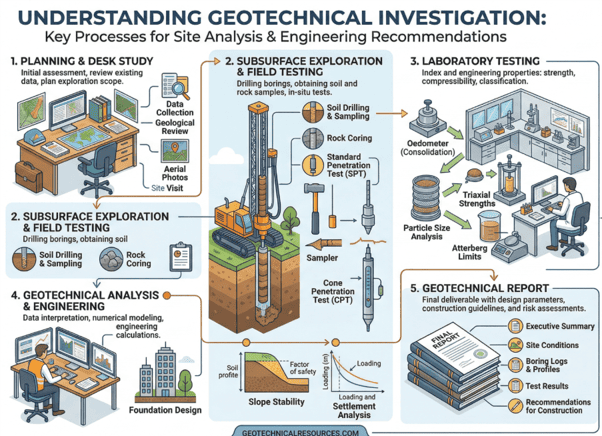
1. Desk Study
The desk study establishes a preliminary understanding of the site using existing information. Typical sources include:
- Historical maps and aerial photography
- Geological and hydrogeological maps
- Records of previous development or industrial activity
- Utility and services information
- Planning history, rights of way, and ownership details
This stage guides the scope of subsequent fieldwork and highlights potential risks such as made ground, peat, karst features, or contamination.
2. Ground Investigation
Intrusive investigation provides direct information on subsurface conditions. Common methods include:
- Trial pits
- Boreholes (shell & auger, rotary coring)
- Dynamic probing
- Plate bearing tests
- Groundwater monitoring
These techniques reveal soil and rock strata, groundwater levels, fill materials, and variability across the site. Samples are collected for laboratory testing.
3. Laboratory Testing
Laboratory analysis characterises the engineering behaviour of the soils and rocks encountered. Typical tests include:
- Classification (moisture content, Atterberg limits, particle size)
- Shear strength (triaxial, direct shear)
- Compressibility and consolidation
- Compaction characteristics
- Rock durability and strength
- Chemical testing (e.g., Rilta Suite) for contamination or aggressive ground conditions
The results provide the parameters needed for safe and economical design.
4. Reporting
The final report consolidates all findings into a clear, actionable document. It typically includes:
- Logs of investigation points
- Stratigraphy and ground model interpretation
- Groundwater assessment
- Engineering parameters for design
- Recommendations for foundations, earthworks, drainage, and temporary works
- Advice on further investigation or monitoring where required
A good report does more than present data it interprets the ground conditions and provides practical guidance for design and construction.
Financial Risk, Certainty, and Project Viability
Unexpected ground conditions remain one of the most common causes of cost overruns in construction. Examples include:
- Soft or compressible subsoils
- High groundwater levels
- Uncontrolled or variable fill
- Contamination
- Buried obstructions or historical structures
Any of these can significantly impact foundation design, earthworks, drainage, or construction sequencing. Early investigation reduces uncertainty, allowing developers and design teams to make informed decisions and avoid expensive surprises.
In practice, every euro spent on investigation can save multiples during construction—through reduced variations, fewer delays, and more predictable design outcomes.
Conclusion
Geotechnical site investigations are not an optional extra; they are a fundamental component of responsible engineering practice. They provide clarity where assumptions would otherwise exist, reduce financial risk, and enable safe, efficient, and economical design. Whether for small developments or major infrastructure, investing in understanding the ground is one of the most cost‑effective decisions a project team can make.
To learn more about how ORS can help you by providing Civil & Structural services, contact us at info@ors.ie or call +353 1524 2060.